2. 南京信息工程大学气象灾害预报 预警与评估协同创新中心 南京 210044
2. Collaborative Innovation Center on Forecast and Evaluation of Meteorological Disasters, Nanjing University of Information Science and Technology, Nanjing 210044, China
越来越多的基于卫星遥感观测提取的归一化植被指数(NDVI)或叶面积指数(LAI)研究表明, 包括中国在内的北半球中高纬度的很多地区近30多年来植被“绿度”(植被覆盖度与生产力)呈升高趋势[1-2]。植被“绿度”的变化会通过调节物质和能量循环来改变水量平衡[3]。植被覆盖度或生产力变化通常主要通过改变冠层截留、蒸发和蒸腾(即蒸散)等过程来影响水循环。然而, 有关植被“绿度”增加尤其是植树造林等活动对水循环造成的影响仍存在较大争论[4]。一些研究指出植树造林/再造林会减少可用水量[5-8]。小流域的流域配对试验表明森林覆盖度升高会增加森林冠层截留和蒸散, 从而减少径流并导致可用水量下降[7, 9]。与此相反, 其他一些区域尺度研究则表明森林覆盖度升高可促进水汽的大范围传输, 提升区域乃至全球尺度的降水, 森林覆盖度增加对水循环具有正效应[10-11]。有关植树造林/再造林等对产水量的影响仍需明晰。
我国造林面积居世界上第一。为减缓环境退化, 自20世纪50年代以来, 中国政府开始大范围的植树造林/再造林等生态恢复工程, 包括在北方地区(东北、北部、西北和黄淮海)开展的诸如“三北防护林体系工程”、“天然林资源保护工程”、“退耕还林还草工程”等[12-16]。这些造林活动减缓了水土流失和生态退化, 促进了CO2吸收, 有效地改善了自然生态环境。但植树造林等所引起的植被“绿度”变化对区域尺度上径流(产水量)的影响还未有一致结论。一些已有研究表明植树造林和生态系统恢复引起的植被覆盖度增加会减少径流[17-18]。例如, 基于水文模型模拟研究表明造林会使黄土高原地区平均产水量降低50%[19]。Xie等[20]则指出植树造林对我国“三北地区”水循环所产生的影响几乎可以忽略。探讨LAI变化对我国北方地区蒸散和产水量的影响尤为迫切。
本研究利用卫星遥感LAI数据和生态过程模型研究2000—2014年间北方地区LAI变化对蒸散和产水量的影响。首先评价了北方地区LAI的变化趋势; 在此基础上采用“去趋势”法去除LAI变化趋势而仅保留其年际变化; 而后分别基于原始LAI序列和去趋势后LAI序列驱动生态系统过程模型模拟北方地区蒸散; 最后基于两种情景比较分析LAI变化对蒸散和产水量的影响, 以期为区域乃至国家植树造林/再造林政策的实施提供科学参考。
1 数据与方法 1.1 研究区域概况本研究中涉及的北方地区包括东北、北部、西北和黄淮海等4个地区。东北地区包括黑龙江、吉林、辽宁3省; 北部地区包括内蒙古和山西2省; 西北地区包括甘肃、宁夏、陕西3省; 黄淮海地区包括北京、天津、河北、河南、山东、江苏和安徽等7省市。北方地区面积广大, 地形复杂, 不同地区的气候特征存在较大差异, 包括了我国大部分的干旱和半干旱地区[21]。2000—2014年东北、北部、西北和黄淮海等4个地区的年降水量变化趋势分别为8.6 mm·a-1、6.3 mm·a-1、3.5 mm·a-1和-3.9 mm·a-1。我国进行大范围的植树造林/再造林等生态恢复工程等主要集中于这些地区。研究北方地区LAI变化对水循环影响具有一定的代表意义。
1.2 蒸散和产水量模拟本研究利用遥感驱动的生态过程模型BEPS(boreal ecosystem production simulator)对北方地区蒸散进行模拟[22]。BEPS模型把冠层分为阳叶和阴叶两部分, 通过积分将瞬时的单叶片尺度模型升至冠层日尺度, 从而实现区域尺度碳水循环过程模拟[23]。BEPS模型将大气降水、冠层截留、林下降水、冠层蒸腾和蒸发、雪融、雪的升华、土壤蒸发、地表和地下径流、下渗及土壤水分变化等水文过程都考虑在内[24-25]。生态系统蒸散包括了植被冠层阴阳叶蒸腾、土壤表面蒸发以及植被冠层截留等[25]。该模型已被广泛用于不同类型陆地生态系统水文过程研究[26-29]。
LAI是BEPS模型中的重要驱动输入。本研究采用由MODIS地表反射率数据(MOD09A1 V05) 和MODIS地表覆被类型数据(MCD12Q1 V051) 驱动基于4尺度几何光学模型的LAI反演算法生成的2000—2014年每8 d的500 m空间分辨率LAI驱动BEPS模型和探究LAI的变化[28, 30]。基于4尺度几何光学模型的LAI反演算法的主要特点是通过考虑太阳天顶角-传感器天顶角-太阳与传感器之间相对方位角变化对反射率和LAI与植被指数之间关系的影响来反演LAI[31]。在加拿大和中国等地区的验证表明, 基于该算法生成的LAI产品质量要优于MODIS LAI。
除LAI外, BEPS模型的主要驱动输入还包括大气CO2浓度数据、土壤数据和地表覆被类型数据和气象要素数据等。1) 气象要素数据是对2000—2014年北方地区内国家基准气象台站的逐日最高气温、最低气温、降水量、相对湿度和日照时数等数据采用反距离权重法进行空间插值[28], 生成覆盖研究区的500 m空间分辨率的逐日气象要素场数据。2) 地表覆被类型数据采用2001—2014年间逐年MODIS地表覆被数据集(MCD12Q1 V051) (500 m分辨率)[32]。考虑到缺乏2000年数据, 选用2001年地表覆被类型替代。3) 土壤数据采用包含砂粒、黏粒、粉粒的体积百分比数据, 该数据以中国1:1 000 000土壤图和全国第2次土壤调查中8 595个土壤质地剖面数据为基础, 采用多边形链接方式, 生成0.008 33的分布图(重采样为500 m)[33]。
基于区域尺度内一年的土壤储水量变化可以忽略的假设, 本研究中的像元和区域尺度的产水量定义为年降水量和模型模拟的蒸散(ET)之差[19]。
1.3 LAI变化对蒸散和产水量影响评价为评价LAI变化对蒸散和产水量影响, 借鉴已有研究[34]对发生显著变化的LAI像元序列进行去趋势处理。去趋势处理可以保持LAI的年际间变化, 而将其随时间变化的线性趋势予以去除[34]。首先采用线性回归模型计算年均LAI在2000—2014年的变化趋势:
| $y = at + b$ | (1) |
式中: y为年均LAI, t为时间(年), a和b分别为斜率和截距。对于发生显著变化(P < 0.05) 的LAI像元根据年均LAI和时间决定的线性回归关系来实现年均LAI变化趋势的去除:
| ${y_r} = y - \overset{\lower0.5em\hbox{$\smash{\scriptscriptstyle\frown}$}}{y} $ | (2) |
式中: yr为去趋势LAI(即线性拟合的残差), y为原始LAI,
| ${y_{\text{n}}} = {y_{2000}} + {y_r}$ | (3) |
式中: yn为新的年均LAI, y2000为2000年的年均LAI。
新的年均LAI序列(yn)保留了年均LAI的年际变化但不存在线性趋势变化。在此基础上, 根据每8 d的LAI与年均LAI的比值将每年的残差yr按比例分配到每8 d LAI序列中, 得到去趋势后每8 d的LAI序列。
利用原始和去趋势后的每8 d LAI序列分别驱动BEPS模型模拟2000—2104年北方地区陆地生态系统ET, 得到两种情景ET(即原始ET和去趋势ET)。对每一个像元尺度而言, 年蒸散即逐日蒸散累加, 产水量(mm·a-1)计算如下:
| $Y = {\text{PRE}} - {\text{ET}}$ | (4) |
式中: Y、PRE和ET分别为产水量、年降水量和年蒸散。比较两种不同情景(基于原始LAI和去趋势LAI)模拟的蒸散和产水量即可评价LAI变化对水循环的影响。
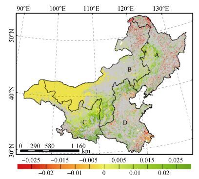
2 结果与分析 2.1 2000—2014年间北方地区LAI变化基于2000—2014年北方地区年均LAI的变化趋势分析表明, 15年间LAI发生显著变化的地区占北方地区总面积的20.2%, 其中LAI显著升高和降低地区面积分别占18.8%和5.5%。东北、北部、西北和黄淮海地区的LAI显著升高比例分别为18.5%、24.9%、25.2%和15.4%;而LAI显著降低比例分别占各区面积的8.3%、5.6%、1.7%和9.0%(图 1)。LAI显著升高的地区主要分布在西北地区东部(黄土高原地区), 东北地区西部和黄淮海地区北部(华北平原), 增长速度约为0.02·a-1。LAI显著下降的地区主要分布在东北地区东部、北部地区北部和黄淮海地区南部和中部零星地区, 下降速度约为0.015·a-1。
|
图 1 2000—2014年北方地区年均LAI变化趋势空间分布[LAI未发生显著变化(P > 0.05) 区域以灰色表示。A、B、C和D依次为东北、北部、西北和黄淮海地区] Figure 1 Trends of annual mean LAI change for the northern China during the period 2000-2014 [The light grey indicates vegetated areas with insignificant trends in annual mean LAI change (P > 0.05). A, B, C and D are Northeast, North, Northwest and Huanghuaihai regions of China, respectively.] |
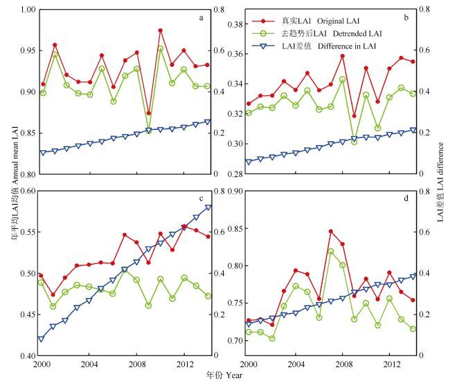
4个地区年均LAI的区域均值统计显示, 北部地区和西北地区LAI在过去15年中分别以0.001 4·a-1(P < 0.05) 和0.004 7·a-1(P < 0.001) 速度显著增长(图 2)。由于LAI升高和降低趋势在一定程度上的相互抵消, 东北地区和黄淮海地区区域平均LAI变化不明显。各地区原始LAI和去趋势后LAI的差值在2000—2014年间均呈显著增长(P < 0.000 1), 其中, 西北地区增幅最大(0.004 5·a-1), 黄淮海地区次之(0.001 7·a-1), 北部地区和东北地区接近相当(0.001 1·a-1)。
|
图 2 2000—2014年间北方地区原始LAI、去趋势后LAI及两者差值的区域均值变化(a、b、c和d依次为东北、北部、西北和黄淮海地区) Figure 2 Spatial-averages of the original LAI, detrended LAI and their difference over the northern China during the period 2000-2014 (Fig. a, b, c and d are Northeast, North, Northwest and Huanghuaihai regions of China, respectively.) |
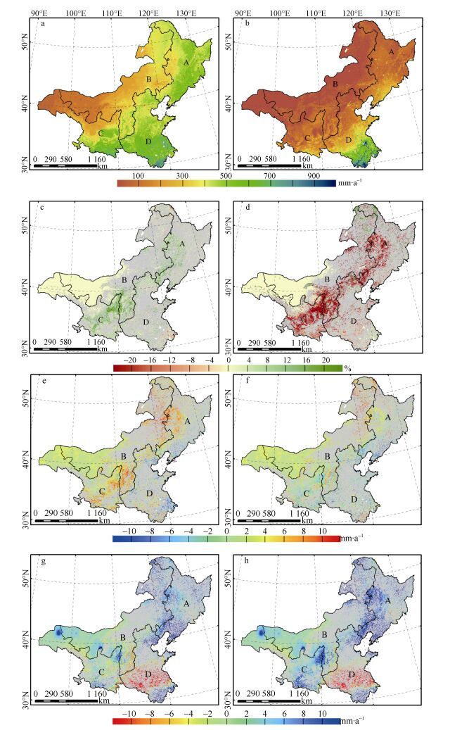
利用原始LAI和去趋势后的LAI分别驱动BEPS模型评价像元尺度上LAI变化对年蒸散和产水量大小和空间格局的影响(图 3a-d)。通过两种情景模拟的年蒸散和产水量2000—2014年的多年均值空间分布比较可以发现, 在像元尺度上LAI升高会促进蒸散并降低产水量, 而LAI降低则相反。LAI升高对蒸散贡献较大的地区主要分布在西北地区中东部、北部地区南部和东北地区西部等LAI明显增长地区(12%~16%)。LAI显著升高对产水量所产生的影响超过了其对蒸散产生的影响, 北方广大LAI升高地区的产水量减少超过20%。LAI降低促进产水量主要发生在东北北部、北方地区北部以及黄淮海东部的零星地区, 这些地区LAI降低导致蒸散在一定程度上减少。LAI变化对蒸散和产水量影响在空间格局大体一致, 但方向相反, 且对产水量影响幅度超过蒸散。
|
图 3 2000—2014年北方地区蒸散、产水量平均值和变化趋势空间分布[a、b为真实状况下的蒸散和产水量多年均值; c、d为LAI变化贡献的蒸散和产水量相对百分比; e、g为真实状况下蒸散和产水量变化趋势; f、h为不考虑LAI变化贡献的蒸散和产水量变化趋势。] Figure 3 Spatial distribution of mean and trends of annual ET and water yield in the northern China over the period 2000-2014 (a and b are annual ET and water yield simulated with original LAI; c and d are the relative differences (%) in annual ET and water yield between the two model simulations. e and g are trends of simulated annual ET and water yield with original LAI, respetively; f and h are trends of simulated annual ET and water yield with detrended LAI, respectively.) |
基于原始LAI和去趋势后LAI模拟结果评价了2000—2014年北方地区年蒸散和产水量的变化趋势(图 3e-h)。2000—2014年间北方大部分地区ET呈增加趋势, 西北地区和东北地区升高尤为明显, 增长速度在8 mm·a-1左右,部分地区ET年增长率甚至接近10 mm·a-1(图 3e)。与原始LAI模拟得到的蒸散变化趋势不同, 去趋势LAI模拟得到的蒸散在LAI升高地区呈现较小的升高趋势, 而在LAI下降地区呈现较小的下降趋势(图 3f)。受同期降水量升高的影响, 除黄淮海中南部地区外, 广大北方地区产水量呈现升高趋势(图 3g), 其中, 黄土高原北部地区、东北地区南部、东北地区和北方地区相邻地区等产水量增长速度超过6 mm·a-1, 零星地区产水量增长甚至超过10 mm·a-1。基于去趋势后LAI模拟得到的产水量变化趋势可以看出, 若不考虑LAI变化贡献, 以上地区的产水量升高速度会更大(图 3h)。以上分析也说明植树造林等活动引起的LAI升高促进了我国北方地区蒸散量, 但却在一定程度上减缓了产水量的升高。
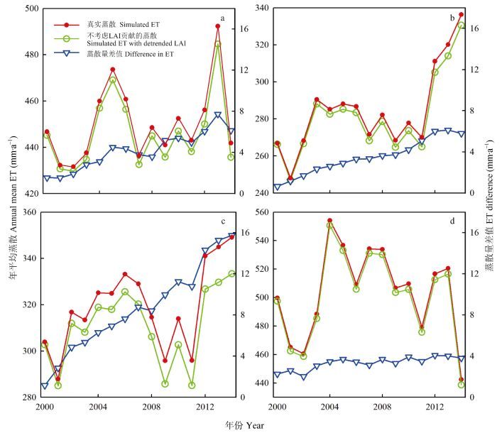
植被LAI变化对水循环影响取决于研究区的覆盖范围和研究区内LAI升高和降低的比例。在区域尺度上, 2000—2014年间北部地区(y=3.52x+256.6, R”=0.47, P < 0.000 1) 和西北地区的区域平均年蒸散显著升高(y=2.14x+302.1, R”=0.27, P < 0.05), 东北地区和黄淮海地区蒸散呈不显著的上升趋势(图 4)。原始LAI和去趋势LAI模拟的蒸散比较表明, 真实蒸散和不考虑LAI贡献蒸散之间差值变化趋势在西北地区差异最为明显(0.95 mm×a-1, P < 0.000 1), 东北地区和北部地区次之(0.38 mm·a-1, P < 0.000 1), 黄淮海地区最小(0.11 mm·a-1, P < 0.001)。这说明在区域尺度上, 北方地区LAI升高促进了年蒸散ET, 而LAI降低减缓年蒸散。随着时间尺度越长LAI变化对蒸散影响越明显。
|
图 4 真实和不考虑LAI变化情况下北方地区平均蒸散区域均值的变化趋势(a、b、c和d依次为东北、北部、西北和黄淮海地区) Figure 4 Spatial-averages of annual ET, simulated annual ET with detrended LAI and their difference for the northern China during the period 2000-2014 (Fig. a, b, c, d are Northeast, North, Northwest and Huanghuaihai regions of China, respectively.) |
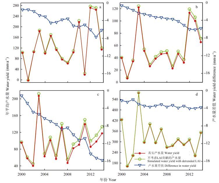
4个地区产水量的区域均值统计来看, 2000—2014年间除黄淮海地区产水量呈现不明显的下降趋势外, 其他3个地区产水量均呈现不显著的升高趋势(图 5)。LAI的变化减缓了4个地区产水量的增长: LAI的变化导致真实产水量和不考虑LAI贡献产水量之间差值在西北地区差异尤为显著, 减缓的年产水量为0.95 mm·a-1(y=-0.95x-1.0, R”=0.97, P < 0.000 1);东北(y=-0.38x-1.15, R”=0.88, P < 0.000 1) 和北部地区(y=-0.38x-0.50, R”=0.96, P < 0.000 1) 次之, 减缓速度约为0.38 mm·a-1(P < 0.000 1);黄淮海地区居末, 减缓速度约为0.11 mm·a-1(y=-0.11x-2.4, R”=0.68, P < 0.001)。真实LAI和去趋势LAI两种情景模拟的2000—2014年产水量区域均值之差在西北地区最大(9.2%), 北部地区(6.6%)和东北地区(3.3%)次之, 黄淮海地区最小(1.1%)。以上结果表明LAI的变化在区域尺度上改变了我国北方地区的产水量变化趋势。
|
图 5 真实和不考虑LAI变化情况下北方地区产水量区域均值的变化趋势(a、b、c和d依次为东北、北部、西北和黄淮海地区) Figure 5 Spatial-averages of actual water yield, simulated water yield with detrended LAI and their difference for the northern China during the period 2000-2014 (Fig. a, b, c, d are Northeast, North, Northwest and Huanghuaihai regions of China, respectively.) |
很多已有研究表明我国北方地区近年来LAI整体呈现升高趋势。LAI的变化受到环境因素和人为因素的综合影响[35-36]。北方地区LAI升高很大原因归结为“三北防护林工程”、“退耕还林还草工程”等大范围造林项目的实施, 农业管理措施改进以及气候变暖、CO2浓度升高和氮沉降等对植被生长的促进[35-36]; 而北方地区LAI降低则主要是生态系统退化和城市化等所导致[37-38]。本研究中采用基于MODIS反演的2000—2014年LAI定量评估北方地区LAI变化以及其对水循环的影响, 监测到LAI变化趋势与前人研究基本一致[34, 39]。本研究通过“去趋势”对LAI随时间升高或者降低的线性趋势予以去除而保留了其年际变化。通过原始LAI和去趋势LAI驱动生态过程模型分析了LAI变化对年蒸散和产水量的影响。
LAI变化尤其是植树造林对产水量影响受到越来越多的关注。一些研究指出植树造林/再造林导致蒸散明显增加和径流减少[40-42]。最近一项全球综合研究表明土地覆被变化对非湿润地区或保水能力差的流域影响较为明显[9]。植树造林/再造林引起LAI变化并通过改变水文和能量循环等对气候变化予以反馈[4]。本研究结果也表明植被LAI的变化对蒸散和产水量的影响在不同空间尺度上存在差异。评价LAI变化对蒸散和产水量的“净影响”需要考虑各种因素的作用。未来相关研究有必要将LAI变化所导致的蒸散及其他因子(如地表粗糙度、地表反照率)的变化对气候的反馈作用纳入进来。
在像元尺度LAI升高通常促进年蒸散量并减少产水量, 而LAI降低则减少年蒸散并促进产水量(图 3a-d); 两种情景模式下蒸散和产水量的差值在区域尺度上分别表现上升趋势和下降趋势, 这说明LAI升高对区域尺度蒸散产生正效应而对产水量存在负效应。另一方面, LAI降低所引起的蒸散降低和产水量增加会部分抵消LAI升高对水循环的影响。这表明植树造林/再造林等导致的LAI变化对水循环的“净影响”取决于空间尺度范围。有关我国北方地区植树造林/再造林工程的可行性近年来颇受争议[43-44]。一方面, 植树造林在提高森林覆盖率, 减少土壤侵蚀, 增强包括碳固定在内的生态系统服务功能等方面都起到了积极作用[45]。另一方面, 植树造林/再造林会增加区域蒸散并降低产水量, 这将加剧我国北方干旱-半干旱地区的水资源短缺问题[43]。我国近年来一直在推进生态系统恢复工程, 在2050年前中国森林覆盖率将达26%[46], 这些工程可能会对我国水循环过程产生更大影响。考虑到广大北方地区的缺水危机和LAI升高对产水量可能产生的负效应, 植树造林活动未来或许应该更多集中于降水更为充沛的南方地区。
3.2 结论LAI变化显著影响着陆地生态系统水循环。本研究基于生态过程模型和遥感数据探究了北方地区LAI变化对蒸散和产水量影响, 得出以下主要结论: 2000—2014年间LAI发生显著变化的地区占北方地区面积的20.2%, 其中LAI显著升高和降低地区面积分别占18.8%和5.5%。在像元尺度上, LAI升高会促进蒸散并降低产水量, LAI降低则相反。在区域尺度上, LAI的升高分别对蒸散和产水量产生了显著的正负效应; LAI变化对蒸散发和产水量影响取决于研究区范围和研究区内LAI升高和降低的比例。
| [1] | Xiao J, Moody A. Geographical distribution of global greening trends and their climatic correlates: 1982-1998[J]. International Journal of Remote Sensing, 2005, 26(11): 2371–2390. DOI:10.1080/01431160500033682 |
| [2] | De Jong R, De Bruin S, De Wit A, et al. Analysis of monotonic greening and browning trends from global NDVI time-series[J]. Remote Sensing of Environment, 2011, 115(2): 692–702. DOI:10.1016/j.rse.2010.10.011 |
| [3] | Bonan G B. Forests and climate change: Forcings, feedbacks, and the climate benefits of forests[J]. Science, 2008, 320(5882): 1444–1449. DOI:10.1126/science.1155121 |
| [4] | Ellison D, Futter M N, Bishop K. On the forest cover-water yield debate: From demand-to supply-side thinking[J]. Global Change Biology, 2012, 18(3): 806–820. DOI:10.1111/j.1365-2486.2011.02589.x |
| [5] | Zhang L, Dawes W R, Walker G R. Response of mean annual evapotranspiration to vegetation changes at catchment scale[J]. Water Resources Research, 2001, 37(3): 701–708. DOI:10.1029/2000WR900325 |
| [6] | Andréassian V. Waters and forests: From historical controversy to scientific debate[J]. Journal of Hydrology, 2004, 291(1/2): 1–27. |
| [7] | Brown A E, Zhang L, McMahon T A, et al. A review of paired catchment studies for determining changes in water yield resulting from alterations in vegetation[J]. Journal of Hydrology, 2005, 310(1/4): 28–61. |
| [8] | Jackson R B, Jobbágy E G, Avissar R, et al. Trading water for carbon with biological carbon sequestration[J]. Science, 2005, 310(5756): 1944–1947. DOI:10.1126/science.1119282 |
| [9] | Zhou G Y, Wei X H, Chen X Z, et al. Global pattern for the effect of climate and land cover on water yield[J]. Nature Communications, 2015, 6: 5918. DOI:10.1038/ncomms6918 |
| [10] | Liu Y Q, Stanturf J, Lu H Q. Modeling the potential of the northern China forest shelterbelt in improving hydroclimate conditions[J]. Journal of the American Water Resources Association, 2008, 44(5): 1176–1192. DOI:10.1111/jawr.2008.44.issue-5 |
| [11] | Jiang B, Liang S L. Improved vegetation greenness increases summer atmospheric water vapor over northern China[J]. Journal of Geophysical Research: Atmospheres, 2013, 118(15): 8129–8139. DOI:10.1002/jgrd.50602 |
| [12] | Chen Y P, Wang K B, Lin Y S, et al. Balancing green and grain trade[J]. Nature Geoscience, 2015, 8(10): 739–741. DOI:10.1038/ngeo2544 |
| [13] | Zhang Y, Peng C H, Li W Z, et al. Multiple afforestation programs accelerate the greenness in the 'Three North' region of China from 1982 to 2013[J]. Ecological Indicators, 2016, 61: 404–412. DOI:10.1016/j.ecolind.2015.09.041 |
| [14] |
黄森旺, 李晓松, 吴炳方, 等.
近25年三北防护林工程区土地退化及驱动力分析[J]. 地理学报, 2012, 67(5): 589–598.
Huang S W, Li X S, Wu B F, et al. The distribution and drivers of land degradation in the three-north shelter forest region of China during 1982-2006[J]. Acta Geographica Sinica, 2012, 67(5): 589–598. DOI:10.11821/xb201205002 |
| [15] |
杨存建, 刘纪远, 张增祥, 等.
遥感和GIS支持下的中国退耕还林还草决策分析[J]. 遥感学报, 2002, 6(3): 205–211.
Yang C J, Liu J Y, Zhang Z X, et al. Decision-marking on returning the dry upland to forest or grass land with support of GIS and remote sensing in China[J]. Journal of Remote Sensing, 2002, 6(3): 205–211. DOI:10.11834/jrs.20020309 |
| [16] |
杨文治.
黄土高原土壤水资源与植树造林[J]. 自然资源学报, 2001, 16(5): 433–438.
Yang W Z. Soil water resources and afforestation in Loess Plateau[J]. Journal of Natural Resources, 2001, 16(5): 433–438. DOI:10.11849/zrzyxb.2001.05.006 |
| [17] | Li S, Xu M, Sun B. Long-term hydrological response to reforestation in a large watershed in southeastern China[J]. Hydrological Processes, 2014, 28(22): 5573–5582. DOI:10.1002/hyp.10018 |
| [18] | Liu W F, Wei X H, Liu S R, et al. How do climate and forest changes affect long-term streamflow dynamics? A case study in the upper reach of Poyang River Basin[J]. Ecohydrology, 2015, 8(1): 46–57. DOI:10.1002/eco.v8.1 |
| [19] | Sun G, Zhou G Y, Zhang Z Q, et al. Potential water yield reduction due to forestation across China[J]. Journal of Hydrology, 2006, 328(3/4): 548–558. |
| [20] | Xie X H, Liang S L, Yao Y J, et al. Detection and attribution of changes in hydrological cycle over the Three-North region of China: Climate change versus afforestation effect[J]. Agricultural and Forest Meteorology, 2015, 203: 74–87. DOI:10.1016/j.agrformet.2015.01.003 |
| [21] |
刘扬, 韦志刚, 李振朝, 等.
中国北方地区降水变化的分区研究[J]. 高原气象, 2012, 31(3): 638–645.
Liu Y, Wei Z G, Li Z C, et al. Study on division of precipitation in northern China[J]. Plateau Meteorology, 2012, 31(3): 638–645. |
| [22] | Liu J, Chen J M, Cihlar J, et al. A process-based boreal ecosystem productivity simulator using remote sensing inputs[J]. Remote Sensing of Environment, 1997, 62(2): 158–175. DOI:10.1016/S0034-4257(97)00089-8 |
| [23] | Chen J M, Liu J, Cihlar J, et al. Daily canopy photosynthesis model through temporal and spatial scaling for remote sensing applications[J]. Ecological Modelling, 1999, 124(2/3): 99–119. |
| [24] | Liu J, Chen J M, Cihlar J. Mapping evapotranspiration based on remote sensing: An application to Canada's landmass[J]. Water Resources Research, 2003, 39(7): 1189. |
| [25] | Chen J M, Chen X Y, Ju W M, et al. Distributed hydrological model for mapping evapotranspiration using remote sensing inputs[J]. Journal of Hydrology, 2005, 305(1/4): 15–39. |
| [26] | Ju W M, Gao P, Wang J, et al. Combining an ecological model with remote sensing and GIS techniques to monitor soil water content of croplands with a monsoon climate[J]. Agricultural Water Management, 2010, 97(8): 1221–1231. DOI:10.1016/j.agwat.2009.12.007 |
| [27] | Liu Y, Zhou Y, Ju W, et al. Evapotranspiration and water yield over China's landmass from 2000 to 2010[J]. Hydrology and Earth System Sciences, 2013, 17(12): 4957–4980. DOI:10.5194/hess-17-4957-2013 |
| [28] | Liu Y, Xiao J, Ju W, et al. Water use efficiency of China's terrestrial ecosystems and responses to drought[J]. Scientific Reports, 2015, 5: 13799. DOI:10.1038/srep13799 |
| [29] |
张方敏, 居为民, 陈镜明, 等.
基于BEPS生态模型对亚洲东部地区蒸散量的模拟[J]. 自然资源学报, 2010, 25(9): 1596–1606.
Zhang F M, Ju W M, Chen J M, et al. Study on evapotranspiration in East Asia using the BEPS ecological model[J]. Journal of Natural Resources, 2010, 25(9): 1596–1606. DOI:10.11849/zrzyxb.2010.09.019 |
| [30] |
柳艺博, 居为民, 陈镜明, 等.
2000—2010年中国森林叶面积指数时空变化特征[J]. 科学通报, 2012, 57(16): 1435–1445.
Liu Y B, Ju W M, Chen J M, et al. Spatial and temporal variations of forest LAI in China during 2000-2010[J]. Chinese Science Bulletin, 2012, 57(16): 1435–1445. |
| [31] | Deng F, Chen J M, Plummer S, et al. Algorithm for global leaf area index retrieval using satellite imagery[J]. IEEE Transactions on Geoscience and Remote Sensing, 2006, 44(8): 2219–2229. DOI:10.1109/TGRS.2006.872100 |
| [32] | Friedl M A, Sulla-Menashe D, Tan B, et al. MODIS collection 5 global land cover: Algorithm refinements and characterization of new datasets[J]. Remote Sensing of Environment, 2010, 114(1): 168–182. DOI:10.1016/j.rse.2009.08.016 |
| [33] | Shangguan W, Dai Y J, Liu B Y, et al. A soil particle-size distribution dataset for regional land and climate modelling in China[J]. Geoderma, 2012, 171-172: 85–91. DOI:10.1016/j.geoderma.2011.01.013 |
| [34] | Xiao J F. Satellite evidence for significant biophysical consequences of the "Grain for Green" program on the Loess Plateau in China[J]. Journal of Geophysical Research: Biogeosciences, 2014, 119(12): 2261–2275. DOI:10.1002/2014JG002820 |
| [35] | Tian H Q, Melillo J, Lu C Q, et al. China's terrestrial carbon balance: Contributions from multiple global change factors[J]. Global Biogeochemical Cycles, 2011, 25(1): GB1007. |
| [36] | Xiao J F, Zhou Y, Zhang L. Contributions of natural and human factors to increases in vegetation productivity in China[J]. Ecosphere, 2015, 6(11): 233. DOI:10.1890/ES14-00394.1 |
| [37] | Li A, Wu J G, Huang J H. Distinguishing between human-induced and climate-driven vegetation changes: A critical application of RESTREND in inner Mongolia[J]. Landscape Ecology, 2012, 27(7): 969–982. DOI:10.1007/s10980-012-9751-2 |
| [38] |
刘爽, 宫鹏.
2000—2010年中国地表植被绿度变化[J]. 科学通报, 2012, 57(16): 1423–1434.
Liu S, Gong P. Change of surface cover greenness in China between 2000 and 2010[J]. Chinese Science Bulletin, 2012, 57(16): 1423–1434. |
| [39] | Chen B Z, Xu G, Coops N C, et al. Changes in vegetation photosynthetic activity trends across the Asia-Pacific region over the last three decades[J]. Remote Sensing of Environment, 2014, 144: 28–41. DOI:10.1016/j.rse.2013.12.018 |
| [40] | Yu P T, Krysanova V, Wang Y H, et al. Quantitative estimate of water yield reduction caused by forestation in a water-limited area in northwest China[J]. Geophysical Research Letters, 2009, 36(2): L02406. |
| [41] | Yao Y F, Cai T J, Ju C Y, et al. Effect of reforestation on annual water yield in a large watershed in northeast China[J]. Journal of Forestry Research, 2015, 26(3): 697–702. DOI:10.1007/s11676-015-0119-8 |
| [42] |
刘贤赵, 谭春英, 宋孝玉, 等.
黄土高原沟壑区典型小流域土地利用变化对产水量的影响——以陕西省长武王东沟流域为例[J]. 中国生态农业学报, 2005, 13(4): 99–102.
Liu X Z, Tan C Y, Song X Y, et al. Impact of land use change on the water yield of typical small watershed in gully region at loess plateau — A case study from Wangdonggou watershed in Changwu, Shaanxi Province[J]. Chinese Journal of Eco-Agriculture, 2005, 13(4): 99–102. |
| [43] | Cao S X. Why large-scale afforestation efforts in China have failed to solve the desertification problem[J]. Environmental Science & Technology, 2008, 42(6): 1826–1831. |
| [44] | Ma H, Lü Y, Li H X. Complexity of ecological restoration in China[J]. Ecological Engineering, 2013, 52: 75–78. DOI:10.1016/j.ecoleng.2012.12.093 |
| [45] | Liu D, Chen Y, Cai W W, et al. The contribution of China's Grain to Green Program to carbon sequestration[J]. Landscape Ecology, 2014, 29(10): 1675–1688. DOI:10.1007/s10980-014-0081-4 |
| [46] |
雷加富.
中国森林资源[M]. 北京: 中国林业出版社, 2005: 172-173.
Lei J F. Forest Resources in China[M]. Beijing: Chinese Forestry Publish House, 2005: 172-173. |
 2017, Vol. 25


