2. 中国环境科学研究院 北京 100012;
3. 中国科学院地理科学与资源研究所 北京 100101;
4. 中国科学院大学 北京 100049
2. Chinese Research Academy of Environmental Sciences, Beijing 100012, China;
3. Institute of Geographic Sciences and Natural Resources Research, Chinese Academy of Sciences, Beijing 100101, China;
4. University of Chinese Academy of Sciences, Beijing 100049, China
农田土壤水是限制农作物生长必需的因素之一, 缺少有效的灌溉制度导致的土壤干旱, 易导致根区环境恶化、作物吸水困难甚至死亡, 而适当灌溉可在一定程度上减轻缺水对作物生长造成的负面影响[1-5]。目前灌溉农业消耗着世界上70%的淡水用水量, 我国农业灌溉水平相比其他发达国家较为落后, 其中华北地区灌溉水利用率仅为0.587[6-10]。华北平原农田灌溉用水多来自于地下水, 对地下水使用与管理造成较大压力且地下水大量开采造成的环境问题十分突出。
目前水分运移预测常用的Gardner模型和van Genuchten模型具有较好的模拟效果, 后者因更高的精确度被广泛使用[11-14]。HYDRUS-1D模型由美国盐土实验室研发, 其中内嵌van Genuchten模型, 可用于分析各种饱和多孔介质中一维垂向的水流和溶质运移, 亦可用于模拟水、热和多种溶质在不同饱和介质中的运动[15-17]。该模型提供了丰富的参数设置及边界条件, 可根据实际情况进行选择。已有学者使用HYDRUS-1D模型模拟土壤水盐运移状态后发现, 盐分随灌水而向下层运动, 且盐分含量随灌水定额的增加而减小[18-20]; 而潘延鑫等[21]使用HYDRUS模型在陕西卤泊滩进行试验并发现, 500 m3∙hm−2的灌溉定额可以有效控制当地土壤积盐。王志坤[22]使用HYDRUS-1D模型对相同灌水定额、不同灌水模式条件下1 m土体内盐分含量做出对比, 发现沟灌模式下土壤平均含盐量低于畦灌模式; 采用不同矿化度的灌水水质可能会使作物严重减产, 但土壤积盐率会随灌水矿化度的增加而增加[23-24]。González等[25]模拟出充分及不充分灌溉下土壤水分运动情况, 其均方根误差为0.014~ 0.025 cm3∙cm−3。探索农田水盐运移规律, 对帮助作物生长及缓解水资源危机均具有重要意义。因此, 使用HYDRUS-1D模型探究和模拟灌溉条件下华北平原地区农田土壤水盐运移规律, 对于提高灌溉水利用效率, 缓解该区域农田灌溉用水压力具有重要意义。
我国HYDRUS-1D模型的应用研究多集中于西北干旱地区, 且多数模拟试验于室外农田开展, 灌水定额难以精确控制, 而针对华北平原小麦(Triticum aestivum)根区范围内土壤水盐运移模拟研究较为空缺。本研究以华北地区中国科学院禹城综合试验站为试验点, 选择当地典型冬小麦农田土壤为研究对象, 采用野外观测和室内土柱试验相结合的方法, 借助HYDRUS-1D软件建立水盐运移模型, 明确模拟软件对研究区水盐运移研究的适配性, 探究华北平原农田水盐运移的规律, 为此模型验证提供数据支撑, 并在优化灌溉管理制度方面建立一定理论基础。
1 研究区概况及研究方法 1.1 研究区概况试验在山东省禹城市中国科学院禹城综合试验站开展, 禹城市地处华北平原中部(36°41′36″~ 37°12′13″N, 116°22′11″~116°45′00″E), 属暖温带大陆季风气候, 年均气温13.3 ℃, 年均降水量555.5 mm, 其中6—9月总降水量约占全年降水量的76%, 月际分布不均匀[26]。境内主要地表径流为徒骇河、赵牛河及潘庄引黄干渠, 主要耕作方式为冬小麦-夏玉米(Zea mays)轮作, 持续的土壤改良使得全区粮食产量从1980年的1.16×10⁵ t增加到2015年的8.28×10⁵ t, 成为华北平原地区典型的产粮地[27]。
1.2 水分运移模拟研究研究利用HYDRUS-1D模型模拟不同深度土壤体积含水率实测值与模拟值, 阐明土壤含水率变化规律, 探究土壤水分变动的驱动因素。选用均方根误差(RMSE)、平均误差(AE)和纳什效率系数(NSE)评价HYDRUS-1D模型对研究区水分运移模拟的适配性并分析模型出现偏差的原因, 其中NSE高于0.75时一般认为模拟结果良好[28]。
1.2.1 土壤含水率实测数据获取选取试验站内长期种植的冬小麦试验田作为试验地, 采用土壤水分廓线系统(Sentek Pty Ltd., 澳大利亚)测定土壤体积含水率, 使用CR200X数据采集器(Campbell Scientific, 美国)采集并记录数据。土壤水分监测系统埋设深度分别为10 cm、20 cm、30 cm、40 cm和60 cm, 频率为每30 min采集数据一次。
1.2.2 土壤水分运移的基本方程土壤体积含水率的计算采用一维Richards方程:
| $\frac{{\partial \theta }}{{\partial t}} = \frac{\partial }{{\partial z}}\left[ {K\left( {\frac{{\partial h}}{{\partial z}} + \cos \alpha } \right)} \right] - S$ | (1) |
式中:
选用van Genuchten-Mualem模型拟合公式(1)中涉及参数:
| $\theta \left( h \right) = \left\{ \begin{array}{l} {\theta _{\rm{r}}} + \frac{{{\theta _{\rm{s}}} - {\theta _{\rm{r}}}}}{{{{\left( {l + {{\left| {h\alpha } \right|}^n}} \right)}^m}}}\;\;\;\;\left( {h < 0} \right) \\ {\theta _{\rm{s}}}\;\;\;\;\left( {h \geqslant 0} \right) \\ \end{array} \right.$ | (2) |
| $K\left( h \right) = {K_{\rm{s}}}S_{\rm{e}}^1{\left[ {l - {{\left( {l - S_{\rm{e}}^{l/m}} \right)}^m}} \right]^2}$ | (3) |
| ${S_{\rm{e}}} = \frac{{\theta - {\theta _{\rm{r}}}}}{{{\theta _{\rm{s}}} - {\theta _{\rm{r}}}}}$ | (4) |
式中: m、n均为土壤水分保持函数中的参数, m=1−1/n, n > 1;
鉴于冬小麦的主根区为地表以下40 cm[30], 故本次水分运移模拟范围选取地表以下80 cm, 空间步长取1 cm, 于10 cm、20 cm、30 cm、40 cm和60 cm处添加观测点。模拟时长50 d, 初始时间步长取0.05 d, 最小时间步长和最大时间步长分别取10−5 d和1 d[31], 根据实测数据, 上、下边界初始含水率分别设置为0.2 cm3∙cm−3、0.48 cm3∙cm−3。由于研究区地下水埋深较大, 多年浮动于4~5 m间[32], 对模拟土层影响可忽略不计, 故分别选择可积水的大气边界、自由排水边界为上、下边界建立模型。运动方程中其余参数根据模型土壤数据库中自带12种土壤特性参数, 及试验地土壤容重和土壤颗粒组成由模型预测得到, 经与实测值校准优化得到参数, 如表 1所示。土壤容重及饱和体积含水率采用环刀法测定, 残余体积含水率采用烘干法称重测定。
| 表 1 试验地土壤基本物理性质和水力学参数 Table 1 Basic physical properties and hydraulic parameters of the experimental soil |
为更精确地控制灌溉水量, 此次盐分运移模拟选择于室内开展土柱试验, 设置定额灌水量, 对比不同时刻土壤剖面含盐量实测值与模拟值, 观测土壤剖面含盐量随时间的变化规律及分布特征; 为探索不同灌水量对土壤盐分运移规律的影响, 进行3次试验, 设置多种灌水量: 8 L、16 L、24 L(对应农田灌溉量6.37 mm、12.73 mm、19.10 mm), 验证HYDRUS-1D模型对研究区盐分运移模拟的可行性并讨论分析模型出现偏差的原因。
1.3.1 土壤中盐分运移的基本方程本次研究选择Equilibrium模型。溶质运动方程如下:
| $\frac{{\partial \left( {\theta \cdot c} \right)}}{{\partial t}} = \frac{\partial }{{\partial z}}\left[ {\theta \cdot D\left( {\frac{{\partial c}}{{\partial z}}} \right)} \right] - \frac{{\partial qc}}{{\partial z}}$ | (5) |
式中: c为土壤溶液中溶质浓度(mg∙cm−3); q为水流通量(cm∙d−1); D为水动力弥散系数(cm2∙d−1);
选择上边界为浓度通量边界, 下边界为零浓度梯度边界, 盐分含量以液相浓度计算。土壤中溶质的运移主要取决于垂向弥散度的大小, 通常室外田间试验的垂向弥散度可取5~20 cm, 本次模拟选择取10 cm[33], 总模拟时长取48 h, 根据实测数据, 设置土壤剖面初始含盐量为0.17 g∙kg−1。
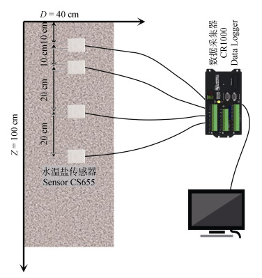
1.3.3 土柱试验本次土壤盐分运移研究制作土柱高Z=100 cm、直径D=40 cm, 在底层铺放滤砂, 防止堵塞排水口, 按照1.33 g∙cm−3容重分层回填土壤, 并在土壤表层铺放碎石, 防止灌水时水流过激, 灌溉用水取自研究区地下水, 矿化度为0.9 g∙L−1。分别在距离土体表面10 cm、20 cm、40 cm、60 cm处开直径为1 cm的孔用以埋设传感器并观测数据。采用CS655水温盐传感器(Campbell Scientific, 美国)、CR1000数据采集器(Campbell Scientific, 美国)监测土壤温度(测量范围: −10~70 ℃; 精度: ±0.5 ℃)、电导率(测量范围: 0~8 dS∙m−1; 精度: ±5%)及含水率(测量范围: 5%~50%; 精度: ±3%), 装置示意图如图 1所示。

|
图 1 土壤盐分运移试验装置示意图 Fig. 1 Schematic diagram of soil salt transport experimental device |
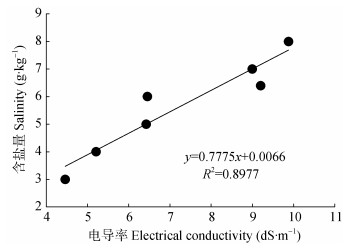
此次试验将待测土样按照土水比1∶5浸提并过滤, 视滤液电导率为土壤电导率(EC), 含盐量(Q)使用蒸干法测定, 并如图 2所示拟合土壤电导率-含盐量标准曲线, 得出Q=0.7775EC+0.0066, R2=0.8977, 相关性较高。后可根据拟合公式由土壤电导率计算出土壤含盐量[34]。

|
图 2 土壤含盐量(Q)与电导率(EC)的关系 Fig. 2 Relationship between soil salinity (Q) and electrical conductivity (EC) |
根据所建模型, 得到土壤不同深度处含水率随时间变动曲线如图 3所示。可以看出浅层(10 cm)土壤体积含水率变化最为剧烈, 体积含水率在0.5 d内从0.23 cm3∙cm−3增加到0.42 cm3∙cm−3。而深层(60 cm)土壤体积含水率在2.3 d内仅从0.41 cm3∙cm−3增加到0.44 cm3∙cm−3。

|
图 3 模拟周期内不同深度土壤含水量实测值与模拟值对比 Fig. 3 Comparison between measured and simulated water contents in different soil depths during the simulation period |
接受补给后, 土壤各含水率随深度依次升高, 且补给对深层土壤的影响远小于对浅层土壤。这说明受到蒸散发作用、浅层土壤及作物吸收、土壤导水率和吸水性能的限制, 外界补给对深层土壤含水率影响很小。土壤体积含水率越大, 吸力值越小, 当土壤含水率趋于饱和时, 吸力值趋于零。
如表 2所示, 水分运移模拟结果的均方根误差平均值为0.0176 cm3∙cm−3, 纳什效率系数平均值为0.826, 变异系数为0.0560, 表示此模型能较好且较稳定地模拟研究区土壤内部水分的运移过程, 可作为研究区水分运移理论研究的有效工具。
| 表 2 不同土层深度土壤水分含量模拟结果验证 Table 2 Verification of simulation results of soil water contents at different soil depths |
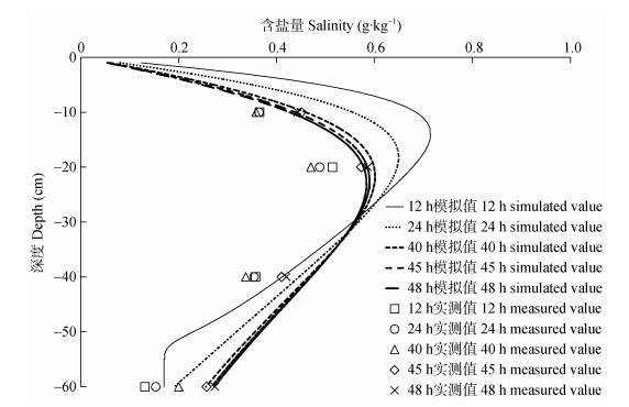
根据所建模型得到土壤盐分运移结果如图 4所示, 12 h时含盐量峰值处于14 cm处, 为0.715 g∙kg−1; 24 h时峰值位置下移至18 cm处, 为0.649 g∙kg−1; 48 h时峰值位置下移至23 cm处, 为0.584 g∙kg−1, 较36 h前降低18.3%, 各时刻盐分含量在垂向上整体呈现先增大后减少的分布规律, 峰值所处位置的下移速度及峰值的减小速度均逐渐降低。

|
图 4 不同时刻土壤含盐量实测值与模拟值对比 Fig. 4 Comparison between measured and simulated soil salinity at different times |
各时刻土壤盐分运移模拟结果验证如表 3所示, 盐分运移模拟结果的均方根误差平均值为0.099 g∙kg−1, 平均误差平均值为0.174 g∙kg−1, 但纳什效率系数的变异系数达到9.71, 表明此模型在部分时刻能较好地模拟研究区土壤盐分的运移过程。
| 表 3 各入渗时间后不同深度土壤盐分含量模拟结果验证 Table 3 Verification of simulation results of salt contents at different soil depths after each infiltration time |
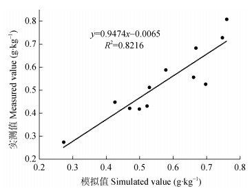
3种灌水量入渗48 h后土壤剖面盐分分布结果如图 5所示, 并如图 6对实测值和模拟值进行相关性分析, 得到决定系数R2为0.8216, 相关性较高。当灌水量增加至16 L、24 L, 入渗48 h后, 其含盐量峰值分别升高为0.720 g·kg−1、0.786 g·kg−1, 相较于灌水量8 L时分别增加23.3%和34.6%; 峰值所处位置分别下移至26 cm、29 cm深度处, 说明灌溉水量的增加会显著加剧土壤中盐分的累积效应。

|
图 5 不同灌水量入渗48 h土壤含盐量实测值与模拟值对比 Fig. 5 Comparison between measured and simulated soil salinity after infiltration form 48 h with different irrigation water amounts |

|
图 6 不同灌水量土壤含盐量模拟值与实测值相关性分析 Fig. 6 Correlation analysis between simulated and measured soil salinity with different irrigation water amounts |
此次研究结果证实, HYDRUS-1D模型可较为精确地模拟研究区农田土壤剖面水分及盐分运移, 5种深度的土壤含水率在接受补给后的整体变动趋势与前人研究所得结论基本一致[19, 25], 其中浅层土壤水盐模拟结果由于受到强烈的气象因素及补给影响, 与实测值偏差较为明显, 随着深度增加, 外界因素的影响逐渐弱化, 模拟结果趋于稳定[35]。但土柱试验所得盐分分布规律与罗朋等[36]的研究结论有所不同, 据其研究所示, 入渗后土壤剖面盐分的分布呈现持续增长的趋势, 即下层土壤的含盐量大于上层土壤。但此次研究表明, 入渗后土壤剖面含盐量应随深度呈现先增长后减少的规律, 即在剖面某深层处出现盐分含量的峰值, 且灌水量越大, 同一深度处盐含量越大, 含盐量峰值越大, 峰值所处位置越深。鉴于土壤水分运移会携带盐分, 故本研究将此次模型计算所得水通量与含盐量变化整理如图 7所示, 结合盐分运移结果可以看出, 土壤剖面内水流通量随时间逐渐减少, 盐分位移也随之减缓, 含盐量累积逐渐达到最大值。这是因为当补给远大于蒸发时, 重力成为水盐运移的主导因素, 盐分跟随水分下移, 且随着水分运移的稳定而逐渐停止, 即会在土壤湿润锋附近出现盐分累积的现象, 郑冬梅[37]的研究结果与这一推测相符。

|
图 7 不同时刻土壤剖面含盐量及水通量变化 Fig. 7 Variations of salinity and water flux in soil profile at different times |
本研究中, 补给初期以及土柱浅层的土壤盐分运移模拟结果与实测值偏差较大。这与浅层土壤接受补给后内部水盐运移过于剧烈有关, 导致模型难以精确计算; 同时由于表层土壤受耕作、根系等人类活动影响, 理化性质变异性较大, 导致模拟值与实测值偏差增大[26]。另一导致模型出现误差的原因笔者分析为土壤环境温度变动, 故绘制土柱内各深度处实测土壤含盐量与实测土壤温度随时间的变化趋势图(图 8), 对比发现土壤各深度含盐量会受温度影响变化且整体与温度呈正相关。此现象与樊会敏等[38]的研究结论相吻合。出现这种现象是因为, 土壤接受补给后, 湿润锋下移并连通上下层土壤毛管水, 每日9:00后气温开始爬升, 下层土壤温度升高, 蒸发导致下层土壤水分携带着盐分依靠毛管力上升并滞留于上层[39], 故相对于蒸发强度较弱时, 在土壤温度变化剧烈的时段内, 模型模拟结果会与实测值产生更大的偏差。

|
图 8 土壤剖面盐分及温度变化趋势 Fig. 8 Variation trends of salinity and temperature in soil profile |
小麦需水量最大的时间段在拔节期到开花期(从3月底至4月底), 日均需水量约5.71 mm; 越冬期到返青期(11月底至翌年3月初)需水量较小, 日均需水量不到0.25 mm, 而小麦在萌芽期对土壤含盐量较为敏感, 其他时期耐盐性较好, 但土壤盐分含量仍不得高于6 dS∙m−1, 否则会导致作物蒸腾量减少, 吸水困难[40-41]。针对此类问题, 可借助HYDRUS模型, 通过改变初始条件、丰富模块参数, 准确且快速地预测土壤中水分及盐分的动态变化, 有效避免不合理灌溉所带来的水资源浪费及作物根区环境恶化等问题。
4 结论以中国科学院禹城综合试验站为研究区, 结合野外长期观测所得土壤水分运移数据及室内土柱试验所得盐分运移数据, 利用HYDRUS-1D模型研究该地区农田水盐运移规律。得出以下结论:
1) 实地监测的土壤初始体积含水率随土壤深度的增加而增加, 发生补给时, 土壤体积含水率随深度陆续增加, 其中浅层土壤的波动最为剧烈, 但受到浅层土壤及作物的吸收、蒸散发作用和吸水性能的限制, 补给对研究区深层(60 cm)土壤含水率影响较小。
2) 借助模型对研究区土壤水盐运移时空分布规律进行模拟, 所得结果与实测值吻合度较高, 表明模型具有较好的仿真性, 可用作研究区水盐运移理论研究的一种有效手段。
3) 增加灌水量导致土柱土壤内盐分向下位移, 表现出显著的农田洗盐效果。发生补给时, 土壤盐分随水分下移, 且随时间的推移, 水分通量的减少对盐分持续运移的影响显著, 导致土壤剖面在不同时刻存在不同深度的积盐区。
| [1] |
冯保清. 我国不同分区灌溉水有效利用系数变化特征及其影响因素分析[J]. 节水灌溉, 2013(6): 29-32. FENG B Q. Analysis on the characteristics and influencing factors of effective utilization coefficient of irrigation water in different regions of China[J]. Water Saving Irrigation, 2013(6): 29-32. DOI:10.3969/j.issn.1007-4929.2013.06.008 |
| [2] |
雷志栋, 胡和平, 杨诗秀. 关于提高灌溉水利用率的认识[J]. 中国水利, 1999(7): 13-14. LEI Z D, HU H P, YANG S X. Awareness of improving the utilization rate of irrigation water[J]. China Water Resources, 1999(7): 13-14. |
| [3] |
王浩, 秦大庸, 郭孟卓, 等. 干旱区水资源合理配置模式与计算方法[J]. 水科学进展, 2004, 15(6): 689-694. WANG H, QIN D Y, GUO M Z, et al. Mode and calculation method for rational water resources allocation in arid zone[J]. Advances in Water Science, 2004, 15(6): 689-694. DOI:10.3321/j.issn:1001-6791.2004.06.001 |
| [4] |
张喜英. 华北典型区域农田耗水与节水灌溉研究[J]. 中国生态农业学报, 2018, 26(10): 1454-1464. ZHANG X Y. Water use and water-saving irrigation in typical farmlands in the North China Plain[J]. Chinese Journal of Eco-Agriculture, 2018, 26(10): 1454-1464. |
| [5] |
QIU G Y, WANG L M, HE X H, et al. Water use efficiency and evapotranspiration of winter wheat and its response to irrigation regime in the North China Plain[J]. Agricultural and Forest Meteorology, 2008, 148(11): 1848-1859. DOI:10.1016/j.agrformet.2008.06.010 |
| [6] |
万书勤, 康跃虎, 王丹, 等. 华北半湿润地区微咸水滴灌对番茄生长和产量的影响[J]. 农业工程学报, 2008, 24(8): 30-35. WAN S Q, KANG Y H, WANG D, et al. Effect of saline water on tomato growth and yield by drip irrigation in semi-humid regions of north China[J]. Transactions of the Chinese Society of Agricultural Engineering, 2008, 24(8): 30-35. DOI:10.3321/j.issn:1002-6819.2008.08.007 |
| [7] |
刘增进, 李宝萍, 李远华, 等. 冬小麦水分利用效率与最优灌溉制度的研究[J]. 农业工程学报, 2004, 20(4): 58-63. LIU Z J, LI B P, LI Y H, et al. Research on the water use efficiency and optimal irrigation schedule of the winter wheat[J]. Transactions of the Chinese Society of Agricultural Engineering, 2004, 20(4): 58-63. |
| [8] |
LI J G, QU Z Y, CHEN J, et al. Effect of different thresholds of drip irrigation using saline water on soil salt transportation and maize yield[J]. Water, 2018, 10(12): 1855. DOI:10.3390/w10121855 |
| [9] |
杨宇, 王金霞, 黄季焜. 农户灌溉适应行为及对单产的影响: 华北平原应对严重干旱事件的实证研究[J]. 资源科学, 2016, 38(5): 900-908. YANG Y, WANG J X, HUANG J K. The adaptive irrigation behavior of farmers and impacts on yield during extreme drought events in the North China Plain[J]. Resources Science, 2016, 38(5): 900-908. |
| [10] |
WEST D W, HOFFMAN G J, FISHER M J. Photosynthesis, leaf conductance, and water relations of cowpea under saline conditions[J]. Irrigation Science, 1986, 7(3): 183-193. DOI:10.1007/BF00344073 |
| [11] |
CHEN G Z, JIAO L F, LI X H. Sensitivity analysis and identification of parameters to the van Genuchten equation[J]. Journal of Chemistry. |
| [12] |
KAWAMOTO K, MOLDRUP P, FERRÉ T P A, et al. Linking the Gardner and Campbell models for water retention and hydraulic conductivity in near-saturated soil[J]. Soil Science, 2006, 171(8): 573-584. DOI:10.1097/01.ss.0000228035.72647.3c |
| [13] |
张露, 王益权, 韩霁昌, 等. 基于van Genuchten模型的渭北苹果园土壤水分能量特征分析[J]. 农业工程学报, 2016, 32(19): 120-126. ZHANG L, WANG Y Q, HAN J C, et al. Analysis on soil moisture energy feature of apple orchards in Weibei area based on van Genuchten model[J]. Transactions of the Chinese Society of Agricultural Engineering, 2016, 32(19): 120-126. DOI:10.11975/j.issn.1002-6819.2016.19.017 |
| [14] |
GHANBARIAN-ALAVIJEH B, LIAGHAT A, HUANG G H, et al. Estimation of the van Genuchten soil water retention properties from soil textural data[J]. Pedosphere, 2010, 20(4): 456-465. DOI:10.1016/S1002-0160(10)60035-5 |
| [15] |
苏雯. 基于HYDRUS的干旱区非饱和土壤入渗性能及水盐运移模拟研究[D]. 乌鲁木齐: 新疆大学, 2017: 13-16 SU W. Simulation of unsaturated soil infiltration and water salt transport in arid area based on HYDRUS[D]. Urumqi: Xinjiang University, 2017: 13-16 |
| [16] |
范严伟, 黄宁, 马孝义, 等. 应用HYDRUS-1D模拟砂质夹层土壤入渗特性[J]. 土壤, 2016, 48(1): 193-200. FAN Y W, HUANG N, MA X Y, et al. Simulation of infiltration characteristics in soil with sand interlayer using HYDRUS-1D[J]. Soils, 2016, 48(1): 193-200. |
| [17] |
李冰冰, 王云强, 李志. HYDRUS-1D模型模拟渭北旱塬深剖面土壤水分的适用性[J]. 应用生态学报, 2019, 30(2): 398-404. LI B B, WANG Y Q, LI Z. Applicability of HYDRUS-1D model in simulating the soil moisture in deep profiles on the Weibei rainfed highland, China[J]. Chinese Journal of Applied Ecology, 2019, 30(2): 398-404. |
| [18] |
余根坚, 黄介生, 高占义. 基于HYDRUS模型不同灌水模式下土壤水盐运移模拟[J]. 水利学报, 2013, 44(7): 826-834. YU G J, HUANG J S, GAO Z Y. Study on water and salt transportation of different irrigation modes by the simulation of HYDRUS model[J]. Journal of Hydraulic Engineering, 2013, 44(7): 826-834. |
| [19] |
ZENG W Z, XU C, WU J W, et al. Soil salt leaching under different irrigation regimes: HYDRUS-1D modelling and analysis[J]. Journal of Arid Land, 2014, 6(1): 44-58. DOI:10.1007/s40333-013-0176-9 |
| [20] |
WU C Y, GAO J S, ZHAO P, et al. Study on the transportation pattern of water and salt in soil of high-density jujube orchards under drip irrigation in South Xinjiang[J]. Acta Horticulturae, 2013(993): 191-198. |
| [21] |
潘延鑫, 罗纨, 贾忠华, 等. 基于HYDRUS模型的盐碱地土壤水盐运移模拟[J]. 干旱地区农业研究, 2017, 35(1): 135-142. PAN Y X, LUO Z, JIA Z H, et al. The simulation of water and salt transportation by HYDRUS model in Lubotan of Shaanxi, China[J]. Agricultural Research in the Arid Areas, 2017, 35(1): 135-142. |
| [22] |
王志坤. 基于不同灌水模式下HYDRUS模型土壤水盐运移模拟研究[J]. 水利技术监督, 2018(6): 39-42. WANG Z K. Soil water and salt transport simulation based on the HYDRUS model under different irrigation modes[J]. Technical Supervision in Water Resources, 2018(6): 39-42. DOI:10.3969/j.issn.1008-1305.2018.06.014 |
| [23] |
MGUIDICHE A, PROVENZANO G, DOUH B, et al. Assessing Hydrus-2D to simulate soil water content (SWC) and salt accumulation under an SDI system: Application to a potato crop in a semi-arid area of central Tunisia[J]. Irrigation and Drainage, 2015, 64(2): 263-274. DOI:10.1002/ird.1884 |
| [24] |
毕远杰, 王全九, 雪静. 覆盖及水质对土壤水盐状况及油葵产量的影响[J]. 农业工程学报, 2010, 26(S1): 83-89. BI Y J, WANG Q J, XUE J. Effects of ground coverage measure and water quality on soil water salinity distribution and helianthus yield[J]. Transactions of the Chinese Society of Agricultural Engineering, 2010, 26(S1): 83-89. |
| [25] |
GONZÁLEZ M G, RAMOS T B, CARLESSO R, et al. Modelling soil water dynamics of full and deficit drip irrigated maize cultivated under a rain shelter[J]. Biosystems Engineering, 2015, 132: 1-18. DOI:10.1016/j.biosystemseng.2015.02.001 |
| [26] |
杨奇勇, 杨劲松, 余世鹏. 禹城市耕地土壤盐分与有机质的指示克里格分析[J]. 生态学报, 2011, 31(8): 2196-2202. YANG Q Y, YANG J S, YU S P. Evaluation on spatial distribution of soil salinity and soil organic matter by indicator Kriging in Yucheng City[J]. Acta Ecologica Sinica, 2011, 31(8): 2196-2202. |
| [27] |
GE D Z, LONG H L, QIAO W F, et al. Effects of rural-urban migration on agricultural transformation: A case of Yucheng City, China[J]. Journal of Rural Studies, 2020, 76: 85-95. DOI:10.1016/j.jrurstud.2020.04.010 |
| [28] |
李玮, 何江涛, 刘丽雅, 等. Hydrus-1D软件在地下水污染风险评价中的应用[J]. 中国环境科学, 2013, 33(4): 639-647. LI W, HE J T, LIU L Y, et al. Application of Hydrus-1D software in groundwater contamination risk assessment[J]. China Environmental Science, 2013, 33(4): 639-647. DOI:10.3969/j.issn.1000-6923.2013.04.009 |
| [29] |
曹巧红, 龚元石. 应用Hydrus-1D模型模拟分析冬小麦农田水分氮素运移特征[J]. 植物营养与肥料学报, 2003, 9(2): 139-145. CAO Q H, GONG Y S. Simulation and analysis of water balance and nitrogen leaching using Hydrus-1D under winter wheat crop[J]. Journal of Plant Nutrition and Fertilizers, 2003, 9(2): 139-145. DOI:10.3321/j.issn:1008-505X.2003.02.002 |
| [30] |
温焕君. 重金属Cd在层状土壤中的运移特征及数值模拟[D]. 青岛: 青岛大学, 2018: 23-25 WEN H J. Migration characteristics and numerical simulation of heavy metal Cd[D]. Qingdao: Qingdao University, 2018: 23-25 |
| [31] |
MA Y, SHAO S Y, SONG X F. Evaluation of optimal irrigation scheduling and groundwater recharge at representative sites in the North China Plain with SWAP model and field experiments[J]. Computers and Electronics in Agriculture, 2015, 116: 125-136. DOI:10.1016/j.compag.2015.06.015 |
| [32] |
何康康, 杨艳敏, 杨永辉. 基于HYDRUS-1D模型的华北低平原区不同微咸水利用模式下土壤水盐运移的模拟[J]. 中国生态农业学报, 2016, 24(8): 1059-1070. HE K K, YANG Y M, YANG Y H. HYDRUS-1D model simulation of soil water and salt movement under various brackish water use schemes in the North China Lowplain[J]. Chinese Journal of Eco-Agriculture, 2016, 24(8): 1059-1070. |
| [33] |
武悦, 王鹏, 李彦标, 等. 巴彦淖尔市耕地土壤中可溶性盐分测定方法探讨[J]. 安徽农学通报, 2018, 24(14): 96-97. WU Y, WANG P, LI Y B, et al. The method of determination of soluble salt in cultivated land of Bayannur City[J]. Anhui Agricultural Science Bulletin, 2018, 24(14): 96-97. DOI:10.3969/j.issn.1007-7731.2018.14.043 |
| [34] |
刘彬彬, 刘尧兵, 张科锋. 基于HYDRUS-1D的不同质地土壤入渗过程数值模拟[J]. 干旱地区农业研究, 2018, 36(4): 140-145. LIU B B, LIU Y B, ZHANG K F. Numerical simulations of water infiltration for various soil textures using HYDRUS 1D[J]. Agricultural Research in the Arid Areas, 2018, 36(4): 140-145. |
| [35] |
WANG Y Q, HU W, ZHU Y J, et al. Vertical distribution and temporal stability of soil water in 21-m profiles under different land uses on the Loess Plateau in China[J]. Journal of Hydrology, 2015, 527: 543-554. DOI:10.1016/j.jhydrol.2015.05.010 |
| [36] |
罗朋, 张富仓, 李晓军, 等. 入渗水头对盐碱土水盐运移影响的试验研究[J]. 节水灌溉, 2008(6): 4-7. LUO P, ZHANG F C, LI X J, et al. Experimental study on influence of infiltration head on water and salt transportation in saline-alkali soil[J]. Water Saving Irrigation, 2008(6): 4-7. DOI:10.3969/j.issn.1007-4929.2008.06.002 |
| [37] |
郑冬梅. 松嫩平原盐渍土水盐运移的节律性研究[D]. 长春: 东北师范大学, 2005: 17-19 ZHENG D M. Study on the temporal rhythm of water and salt transference of alkalization soil in Songnen Plain[D]. Changchun: Northeast Normal University, 2005: 17-19 |
| [38] |
樊会敏, 张蓉蓉, 许明祥, 等. 渭北地区土壤剖面电导率年内动态变化及影响因素[J]. 西北农林科技大学学报: 自然科学版, 2018, 46(8): 107-115. FAN H M, ZHANG R R, XU M X, et al. Seasonal changes and influencing factors of soil electrical conductivity in soil profile of Weibei region[J]. Journal of Northwest A & F University: Natural Science Edition, 2018, 46(8): 107-115. |
| [39] |
乔江飞, 王海江, 李亚莉, 等. 莫索湾灌区土壤剖面盐分的季节性变化特征[J]. 中国土壤与肥料, 2016(3): 13-18. QIAO J F, WANG H J, LI Y L, et al. Spatial variability of soil salinity in different seasons in Mosuowan irrigation area[J]. Soils and Fertilizers Sciences in China, 2016(3): 13-18. |
| [40] |
许振柱, 李长荣, 陈平, 等. 土壤干旱对冬小麦生理特性和干物质积累的影响[J]. 干旱地区农业研究, 2000, 18(1): 113-118. XU Z Z, LI C R, CHEN P, et al. Effects of soil drought on physiological characteristics and dry matter accumulation of winter wheat[J]. Agricultural Research in the Arid Areas, 2000, 18(1): 113-118. DOI:10.3321/j.issn:1000-7601.2000.01.020 |
| [41] |
LEKAKIS E H, ANTONOPOULOS V Z. Modeling the effects of different irrigation water salinity on soil water movement, uptake and multicomponent solute transport[J]. Journal of Hydrology, 2015, 530: 431-446. DOI:10.1016/j.jhydrol.2015.09.070 |
 2021, Vol. 29


